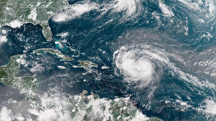
Hurricane Erin has intensified into a powerful Category 4 storm as it moves across the Caribbean, according to the U.S. National Hurricane Centre.
As of Saturday, August 16, Erin was positioned about 240 kilometers northeast of Anguilla, carrying maximum sustained winds of around 230 kilometers per hour.
The storm is advancing west-northwest at 31 kilometers per hour and could strengthen even further due to unusually warm sea temperatures.
Meteorologists have warned that Erin has the potential to reach Category 5 status in the coming days.
The hurricane’s center is expected to remain offshore, but its outer bands are already affecting the northern Leeward Islands.
Authorities have issued flash flood warnings across the region, while tropical storm watches remain in effect for Anguilla, Barbuda, St. Martin, St. Barts, Saba, St. Eustatius, and St. Maarten. Heavy rainfall, flooding, and the risk of landslides remain major concerns for these islands.
Beyond direct impacts, Erin is generating dangerous ocean swells that are spreading widely across the northern Leeward Islands, Virgin Islands, Puerto Rico, Hispaniola, and the Turks and Caicos.
Forecasters expect these conditions to extend to the Bahamas, Bermuda, and parts of the U.S. East Coast early next week, creating hazardous rip currents and unsafe seas even in areas far from the storm’s core.
Officials are urging coastal communities to remain alert as Erin continues to intensify.
While the storm’s track keeps its eye offshore, its broad reach means millions across the Caribbean and Atlantic basin could feel its effects in the days ahead.